skip to main |
skip to sidebar
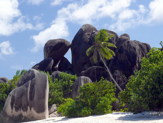


 Anse Source D'Argent, the second best beach in the Seychelles is also one of the most popular.The coastline is a series of small crescent pink sand beaches separated by gigantic granite boulders which are famous for their unusual curves worn by time and weather.. The beach is sheltered by a reef, ideal for snorkeling and sun bathing. The calm waters make it perfect for the little ones.The archipelago of Seychelles, composed of more than 100 palm tree-studded islands in the midst of the Indian Ocean, is a mostly undiscovered destination for American travelers. Dedicated beachcombers who make the trek will, however, be rewarded with some of the most paradisical shores in the world, where beautiful secluded beaches and idyllic lagoons meet with unspoiled natural landscapes echoing with exotic bird songs – don’t miss picture-perfect Anse Source d’Argent, featuring fine pink sands; towering, weathered granite boulders; and giant, arching palm trees.
 History of Kaikoura, New Zealand.
In Maori lore the peninsula was the place where Maui braced his foot when he fished up the North Island and was named Te taumanu o te whaka a Maui ; the thwart of Maui's canoe. The name Kaikoura, meaning meal of crayfish, was given by Tamaki-te-rangi when he stopped over to eat here while chasing his runaway wives. It is likely that Kaikoura was first settled by the Waitaha followed by the Ngati Mamoe and then the Ngai Tahu tribes.
As Moa numbers declined crops and settlements became more important so they built lookouts and fortifications around their hilltop pa sites. Although they were only occupied for short times there are at least fifteen of these pa sites in and around Kaikoura with fierce battles occurring at some of them.
In 1843 Captain Robert Fyfe, reputed to be Kaikoura's earliest European settler, established "Waiopuka", the first shore whaling station near where his house, built in 1860, still stands on it's whale bone piles. Other whaling stations soon followed at South Bay but after 1850 whale numbers steadily declined and the exploitation of them became uneconomic. Today all marine mammals are protected in New Zealand and the whales are hunted with cameras instead of harpoons. Sheep and goats were introduced to the area by him in 1849 and in 1854 he was joined by his cousin George who leased an area north of Kaikoura known as the "Mount Fyffe Run" thus Mount Fyffe got it's name and farming began in the district.
Overland routes to Kaikoura were extremely difficult to travel with rough country and many river crossings. As a result most people and freight traveled by sea despite the often perilous coastline with it's changeable weather resulting in many shipwrecks. The remains of an old chimney near Fyffe House are all that is left of the former custom house, the official port of entry and the main link with the outside world for many years. With land access being improved by the construction of roads and bridges the old port was closed in 1949. The Christchurch to Picton Railway, a major accomplishment complete with 21 tunnels, was opened during 1945.
Like many rural areas of New Zealand, Kaikoura suffered from the economic downturn of the 1980's but is now on the road to recovery.
Tourism got a boost in 1989 when whale watching began. This has brought about an increased awareness of the areas varied and unique wildlife along with an amazing mixture of geological features providing scenery equal to or better than that seen anywhere.
Article from : http://www.virtual-kaikoura.com/history/history.htm
look more picture of kaikoura in new zealand above :


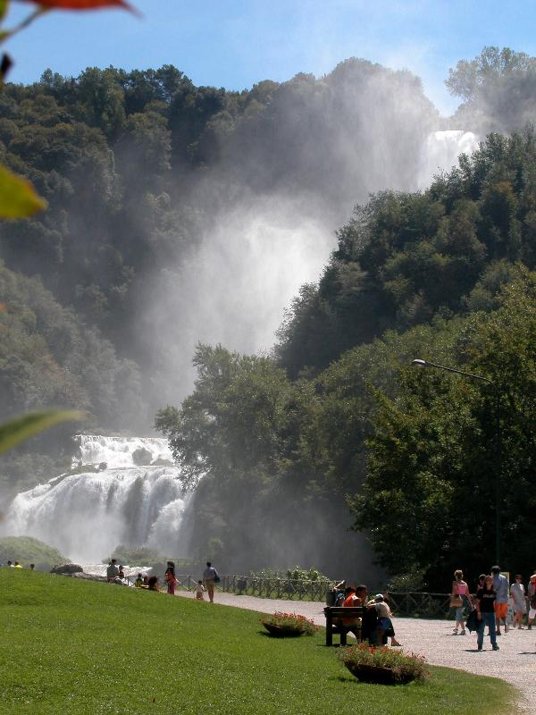
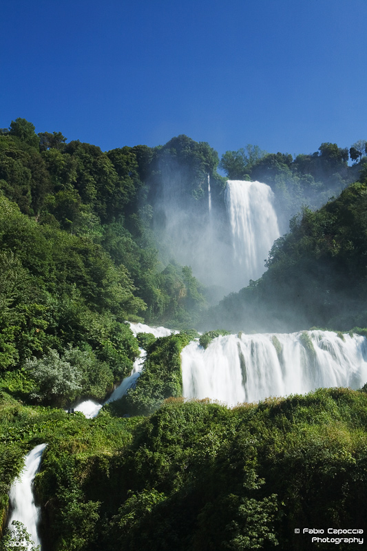
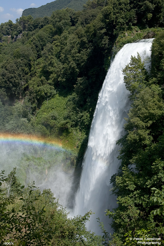

 The Cascata delle Marmore (Marmore's Falls) is a man-made waterfall created by the ancient Romans. Its total height is 165 m (541 feet), making it one of the tallest in Europe and the tallest man-made waterfall in the world. Of its 3 sections, the top one is the tallest, at 83 m (272 feet).It is located 7.7 km from Terni, a provincial capital of the Italian region of Umbria.Its source is a portion of the waters of the river Velino (the rest of the river flows into a hydroelectric power plant), after flowing through Piediluco lake near the community of Marmore. It pours into the valley below formed by the river Nera. Its flow is turned on and off according to a published schedule, to satisfy the needs of tourists and the power company alike. Tourists try to be there the moment the gates are opened to see the powerful rush of water.History :The Velino river flows through the highlands that surround the city of Rieti. In ancient times, it fed a wetland that was thought to bring illness (probably malaria). To remove that threat to the city of Rieti, in 271 BC, the Roman consul Manlius Curius Dentatus ordered the construction of a canal (the Curiano Trench) to divert the stagnant waters into the natural cliff at Marmore. From there, the water fell into the Nera river below. However, that solution created a different problem: when the Velino river was in flood stage, its water flowed through the Nera toward the city of Terni, threatening its population. The issue was so contentious between the two cities that the Roman Senate was forced to address it in 54 BC. Cicero represented Terni, and Aulus Pompeius represented Rieti. The Senate did nothing about the problem, and things remained the same for centuries.Lack of maintenance in the canal resulted in a decrease in the flow, until eventually the wetland began to reappear. In 1422, Pope Gregory XII ordered the construction of a new canal to restore the original flow (the Gregorian Trench or Rieti Trench).In 1545, Pope Paul III ordered that a new canal be built (the Pauline Trench). The plan was to expand the Curian Trench and to build a regulating valve to control the flow. Upon its completion some 50 years later (in 1598), Pope Clement VIII inaugurated the new work, and named it after himself: the Clementine Trench.In the following two centuries, the presence of the canal was problematic for the countryside in the valley below, as the Nera often flooded it. In 1787, Pope Pius VI ordered architect Andrea Vici to modify the leaps below the falls, giving the falls its present look and finally resolving the majority of the problems.In 1896, the newly formed steel mills in Terni began using the water flow in the Curiano Trench to power their operation. In the following years, engineers began using the water flow to generate electricity.source : http://en.wikipedia.org/


 Mini History :Angel Falls (indigenous name: Parakupa-vena or Kerepakupai merú which means the fall from the highest point, in Pemon language; Spanish: Salto Ángel) is the world's highest waterfall, with a height of 979m (3,212ft) and a clear drop of 807m (2,647ft). It is located in the Canaima National Park (Spanish: Parque Nacional Canaima) , in the Gran Sabana region of Bolivar State, Venezuela.The height of the falls is so great that before getting anywhere near the ground, the water is atomized by the strong winds and turned into mist. The mist can be felt a mile away. The base of the falls feeds into the Kerep River (alternately known as the Rio Gauya) which flows into the Churun River, a tributary of the Carrao River.In the indigenous Pemon language Angel Falls is called Kerepakupai merú meaning "waterfall of the deepest place". The falls are sometimes referred to as Churun-meru, an error, since that name corresponds to another waterfall in the Canaima National Park. Churun in the Pemon language means "thunder". article source : http://en.wikipedia.org/


